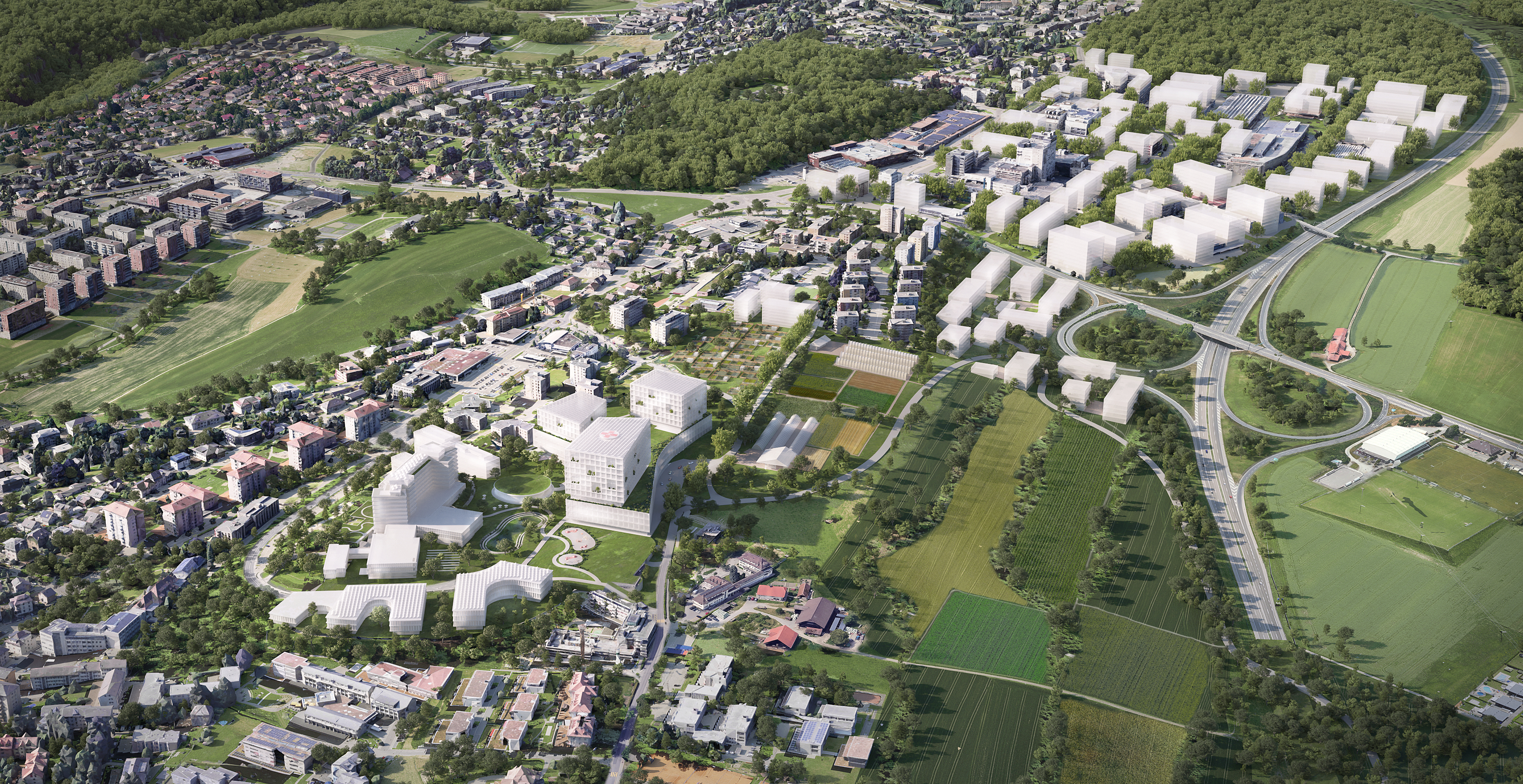
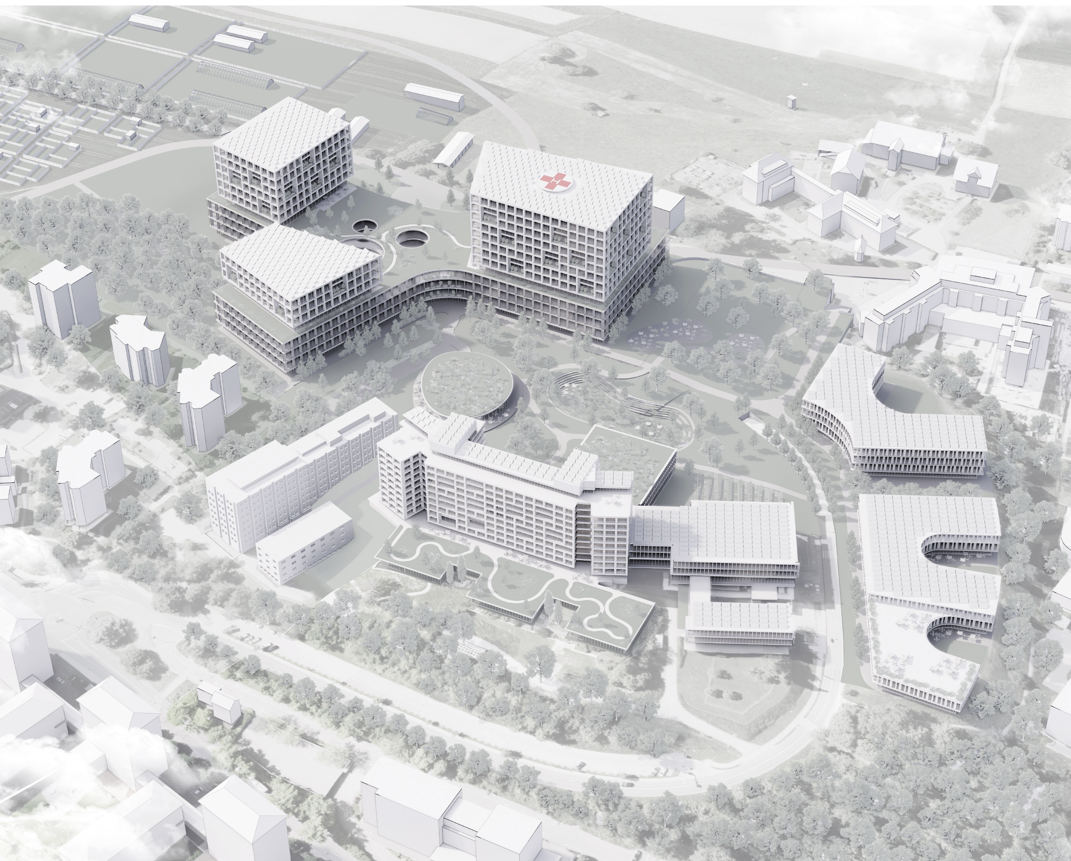
014 Health and Activities Hub, Fribourg
Type of mandate: Study Commission with pre-selection
Client: Canton of Fribourg
Study period: 2023–24
Built area: Hospital 150’000 sqm, University Campus 20’000 sqm, Activities 530’000 sqm
Project perimeter: 1’200’000 sqm (120 ha)
Programs: Cantonal Hospital (HFR), crafts and industries, services, education, parking, shops
Urban Design (pilote): Djurdjevic Architectss, Lausanne
Muriz Djurdjevic (Project Lead)
Architecture: 3XN Architects, Copenhagen
Stig Vesterager Gothelf, Antoine Béchet, Wiktor Kacprzak, Béla Steiner
Architecture: IB+, Lausanne
Catherine Jaquier-Bühler, Marwen Feriani, Georgia Malapani
Landscaping: Forster Paysages, Lausanne
Jan Forster, Simon Cerf-Carpentier, Michele Falco, Ludovic Heimo
Sustainability: IB+, Lausanne
Arnaud Paquier, Stéphane Stutz, Juliette Vincent
Sustainability: GXN Innovation, Copenhagen
Mattia di Carlo, Carolina Felix
Mobility: RGR Ingénieurs, Lausanne
Olivier Schorer,
Images: 3XN/GXN, Copenhagen
RESILIO: A Strategy of Balance, Resilience and Innovation
The RESILIO project embodies a long-term strategic vision, grounded in resilience against uncertainties and the flexibility required for a constantly evolving world. It represents the most robust and least risky approach, fully meeting the project brief while preserving room for adaptation. This stance ensures multiple levels of success, even in the case of partial implementation, and guarantees the sustainability of the initial choices.
Sobriety: Making Use of What Already Exists
RESILIO prioritises the "already there", thus limiting both economic and ecological costs. Rather than heavily artificialising the area, the project proposes a gradual and reversible development, allowing for continuous reassessment of needs. It ensures optimal operation even on a small scale, without blocking the future evolution of the site.
Resilience: Territorial and Planning Resilience
We integrate a dual resilience: territorial, through the preservation of fertile soils, a non-renewable common good; and strategic, through open, concerted, and resource-efficient planning. The proposed urban planning limits artificialisation and encourages a participatory process involving all stakeholders. This approach significantly reduces the risk of legal challenges or opposition from citizens.
For the Health Hub and the new hospital, the chosen location maximises existing advantages: immediate availability of land, infrastructure networks already in place (water, electricity, etc.), and a precise understanding of the soil. These choices reduce uncertainties, save several years on the timeline, and limit implementation costs.
Anticipation and Adaptability
The project creates a physical and legal framework conducive to hosting economic activities aligned with the canton’s climate and regional policies. The lack of excessive artificialisation preserves significant adaptability for the future needs of businesses, while ensuring a strategic land reserve for the municipality and the canton. For the hospital, the flexible phasing and the possibility of adjusting the building's size preserve long-term development options.
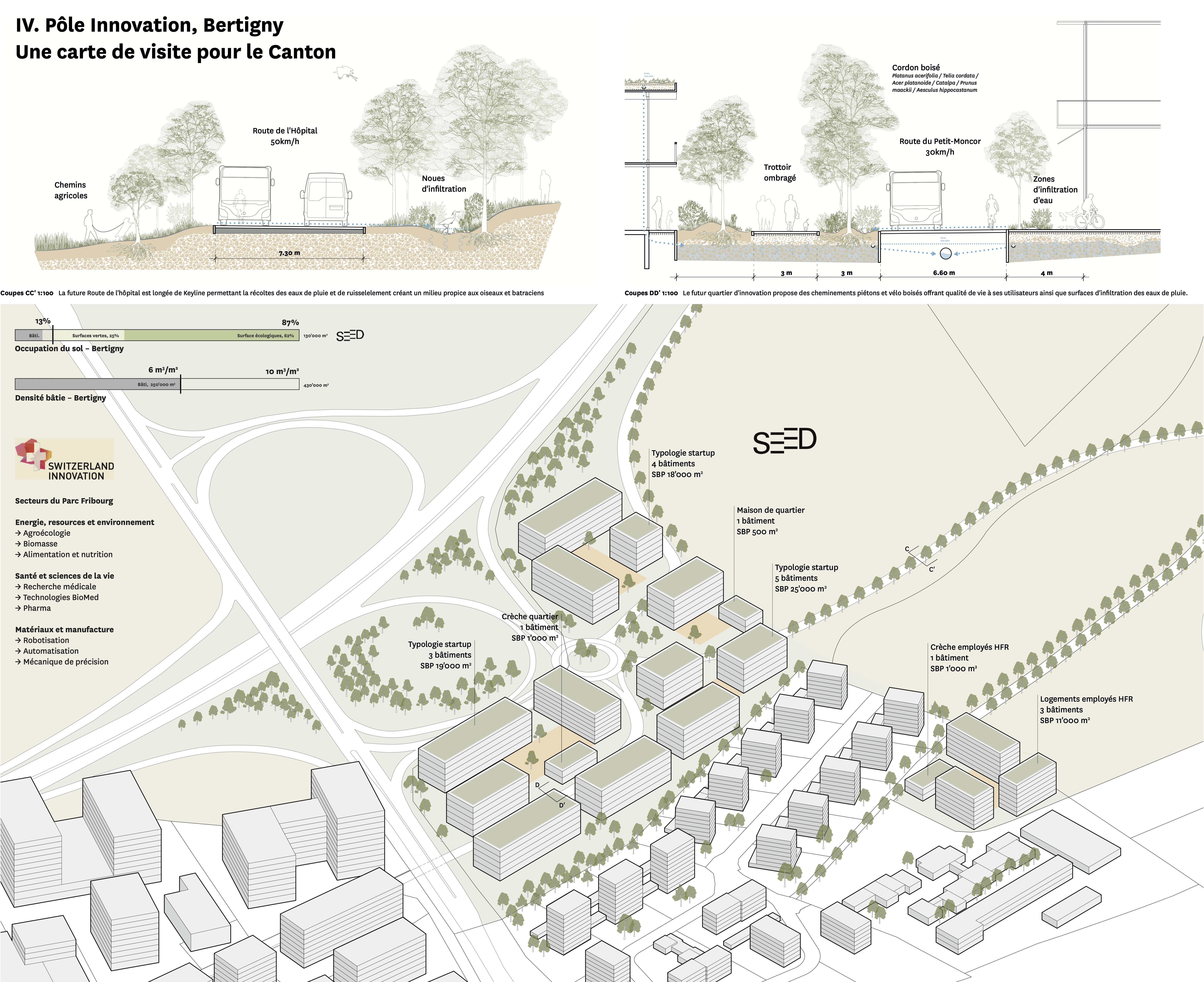
Innovation: A Campus at the Heart of Fribourg’s Synergies
RESILIO proposes the creation of an innovation campus, a catalyst for visibility for Villars-sur-Glâne and Fribourg on a national and international scale. Located at the strategic crossroads of the Moncor manufacturing hub, the agroecological Agricultural Park, and the health and medical research campus,
this campus would be designed as an ecosystem of industrial synergies, integrating clean-tech, applied research, and sustainable production. It would become the gateway to Fribourg, positioning Bertigny as a centre of excellence for the economy of tomorrow.
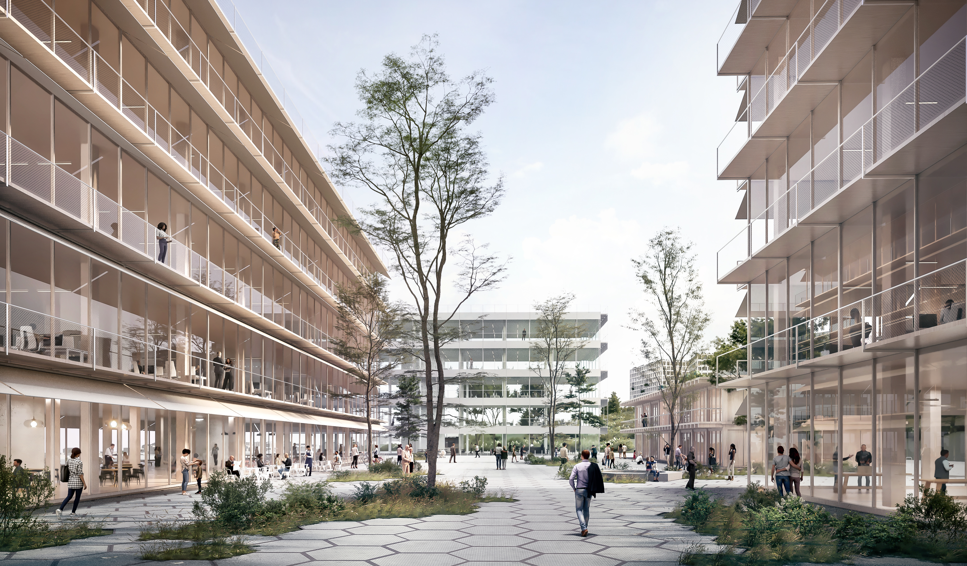
Landscape Concept
The project is based on two founding principles inspired by the Fribourg region: the urban plot and the agricultural countryside. Vegetation is the central element, crossing the entire area, whether built or cultivated. It gives rise to a unifying biological corridor, weaving ecological and visual links between the different neighbourhoods.
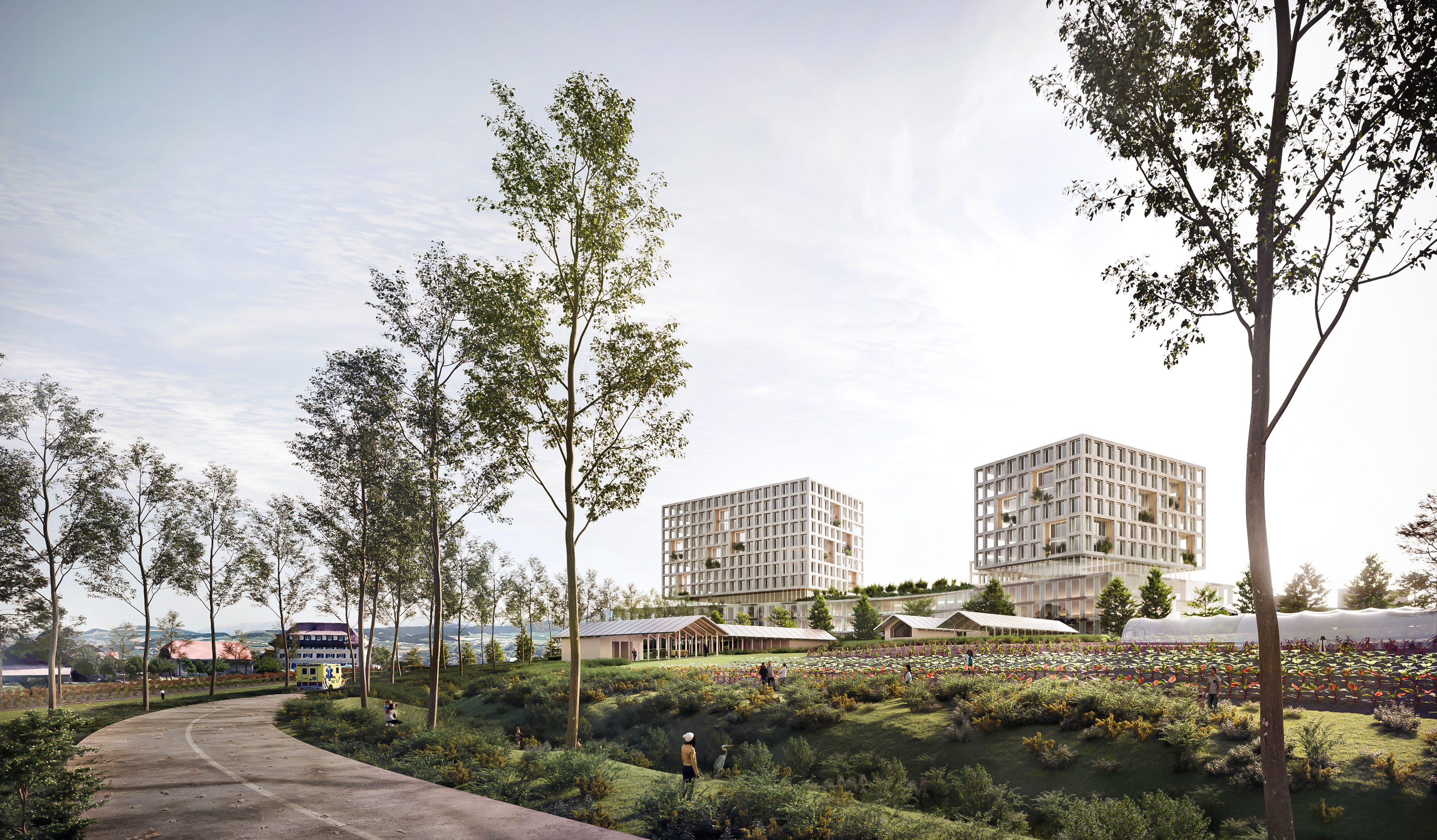
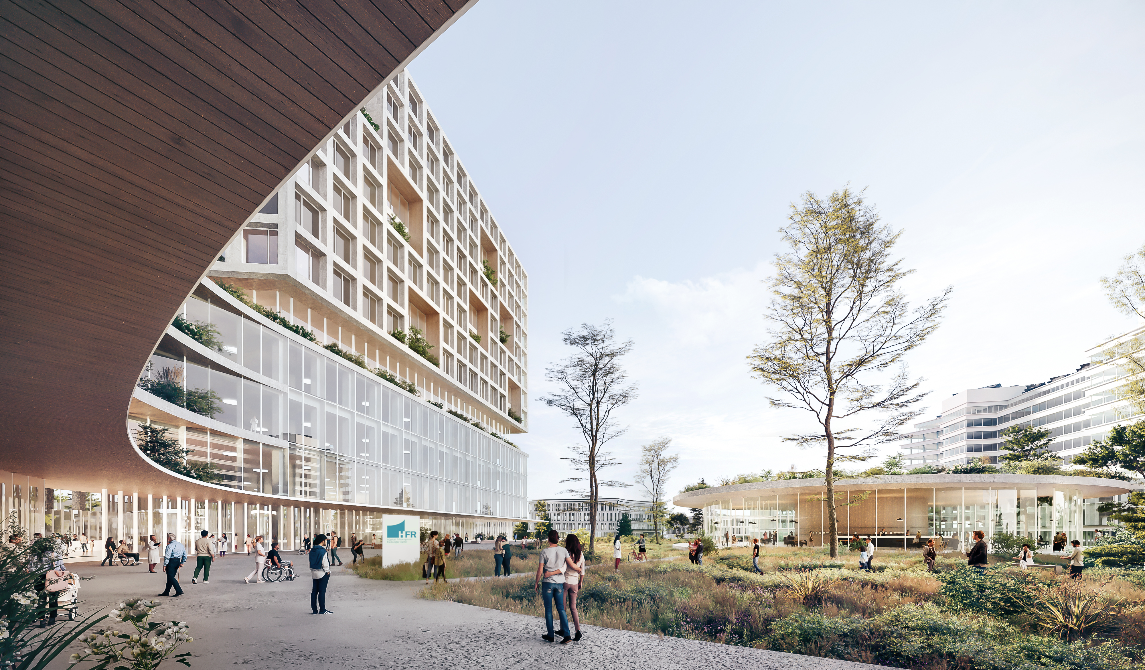
The location of the new hospital is designed to mark the skyline of Fribourg: an iconic building, visible from the surrounding areas, which will offer patients privileged views of the Alps and the Jura. To the north, the Agri-Park will evolve into agroforestry fields, following a landscape framework structured by hedges and rows of trees (keyline system) planted along contour lines. These plantings will serve a dual purpose: creating a nurturing and resilient landscape, and providing forage during dry periods.
Worker’s gardens, promenades, and various educational and recreational uses will animate the space to make it accessible and usable by all. The Agri-Park is structured according to a modular grid, with different scales of mesh, allowing for the creation of plots adapted to the needs of its users: individuals (vegetable gardens), associations (micro-farms), and professionals (market gardening or hedge squares).
The continuity of vegetation and the preservation of the local canopy reinforce the ecological integration of the whole area and the connection between the cultivated plots. The sustainability of the place will depend on the collective experience developed there. The Agri-Park will be framed by a hybrid urban fringe, partly built, partly vegetative, ensuring a smooth and constructive transition with the city. This fringe will host the institutional farm, social and economic activities in light structures, designed to foster neighbourhood life. A true interface between the city and nature, it will form a living skin between the urban and the park.
Maintaining Fertile and Arable Soils
An in-depth pedological analysis of the area, including the family gardens, the Bertigny micro-farm, and the future Agricultural Park, has identified the most favourable zones for the root development of plants. This study provides a unique opportunity to integrate, within the framework of urban development, concrete measures to improve soil quality, particularly in currently degraded areas.
Marked differences in soil depth have been identified across the site. To the north of the motorway, the average soil depth is about 30 cm, corresponding to a soil reconstructed on a motorway embankment. In contrast, to the south, this depth varies between 70 cm and 1 metre, revealing a much better rooting capacity.
The most suitable area for planting large trees is located in the heart of the Agricultural Park, where the soils are deepest. Conversely, the area between the Villars-Vert district and the motorway entrance/exit, closer to the infrastructure, has shallow soils. This area has therefore been prioritised for the development of infrastructure and buildings within the strategic reserve zones.
A soil revitalisation strategy is planned, particularly through the recovery and repositioning of pedological horizons A, B, and C from the excavated land. This approach will help improve depleted soils, particularly in the northern areas and along the motorway.
At the same time, the most fertile soils of the Agricultural Park will be progressively enhanced and enriched. Various substitute environments will be created to increase the organic carbon content of the soils (OCS) and promote biodiversity: permanent, non-trampled meadows, wetlands, and wooded areas will partially replace lands currently intensively cultivated.
This transformation will contribute to increasing the CO₂ sequestration capacity and water retention of the soils, while ensuring their long-term resilience. Coupled with sustainable farming practices, it will promote the conservation and accumulation of organic carbon stocks in arable soils.
Type of mandate: Study Commission with pre-selection
Client: Canton of Fribourg
Study period: 2023–24
Built area: Hospital 150’000 sqm, University Campus 20’000 sqm, Activities 530’000 sqm
Project perimeter: 1’200’000 sqm (120 ha)
Programs: Cantonal Hospital (HFR), crafts and industries, services, education, parking, shops
Urban Design (pilote): Djurdjevic Architectss, Lausanne
Muriz Djurdjevic (Project Lead)
Architecture: 3XN Architects, Copenhagen
Stig Vesterager Gothelf, Antoine Béchet, Wiktor Kacprzak, Béla Steiner
Architecture: IB+, Lausanne
Catherine Jaquier-Bühler, Marwen Feriani, Georgia Malapani
Landscaping: Forster Paysages, Lausanne
Jan Forster, Simon Cerf-Carpentier, Michele Falco, Ludovic Heimo
Sustainability: IB+, Lausanne
Arnaud Paquier, Stéphane Stutz, Juliette Vincent
Sustainability: GXN Innovation, Copenhagen
Mattia di Carlo, Carolina Felix
Mobility: RGR Ingénieurs, Lausanne
Olivier Schorer,
Images: 3XN/GXN, Copenhagen
RESILIO: A Strategy of Balance, Resilience and Innovation
The RESILIO project embodies a long-term strategic vision, grounded in resilience against uncertainties and the flexibility required for a constantly evolving world. It represents the most robust and least risky approach, fully meeting the project brief while preserving room for adaptation. This stance ensures multiple levels of success, even in the case of partial implementation, and guarantees the sustainability of the initial choices.
Sobriety: Making Use of What Already Exists
RESILIO prioritises the "already there", thus limiting both economic and ecological costs. Rather than heavily artificialising the area, the project proposes a gradual and reversible development, allowing for continuous reassessment of needs. It ensures optimal operation even on a small scale, without blocking the future evolution of the site.
Resilience: Territorial and Planning Resilience
We integrate a dual resilience: territorial, through the preservation of fertile soils, a non-renewable common good; and strategic, through open, concerted, and resource-efficient planning. The proposed urban planning limits artificialisation and encourages a participatory process involving all stakeholders. This approach significantly reduces the risk of legal challenges or opposition from citizens.
For the Health Hub and the new hospital, the chosen location maximises existing advantages: immediate availability of land, infrastructure networks already in place (water, electricity, etc.), and a precise understanding of the soil. These choices reduce uncertainties, save several years on the timeline, and limit implementation costs.
Anticipation and Adaptability
The project creates a physical and legal framework conducive to hosting economic activities aligned with the canton’s climate and regional policies. The lack of excessive artificialisation preserves significant adaptability for the future needs of businesses, while ensuring a strategic land reserve for the municipality and the canton. For the hospital, the flexible phasing and the possibility of adjusting the building's size preserve long-term development options.
Innovation: A Campus at the Heart of Fribourg’s Synergies
RESILIO proposes the creation of an innovation campus, a catalyst for visibility for Villars-sur-Glâne and Fribourg on a national and international scale. Located at the strategic crossroads of the Moncor manufacturing hub, the agroecological Agricultural Park, and the health and medical research campus,
this campus would be designed as an ecosystem of industrial synergies, integrating clean-tech, applied research, and sustainable production. It would become the gateway to Fribourg, positioning Bertigny as a centre of excellence for the economy of tomorrow.
Landscape Concept
The project is based on two founding principles inspired by the Fribourg region: the urban plot and the agricultural countryside. Vegetation is the central element, crossing the entire area, whether built or cultivated. It gives rise to a unifying biological corridor, weaving ecological and visual links between the different neighbourhoods.
The location of the new hospital is designed to mark the skyline of Fribourg: an iconic building, visible from the surrounding areas, which will offer patients privileged views of the Alps and the Jura. To the north, the Agri-Park will evolve into agroforestry fields, following a landscape framework structured by hedges and rows of trees (keyline system) planted along contour lines. These plantings will serve a dual purpose: creating a nurturing and resilient landscape, and providing forage during dry periods.
Worker’s gardens, promenades, and various educational and recreational uses will animate the space to make it accessible and usable by all. The Agri-Park is structured according to a modular grid, with different scales of mesh, allowing for the creation of plots adapted to the needs of its users: individuals (vegetable gardens), associations (micro-farms), and professionals (market gardening or hedge squares).
The continuity of vegetation and the preservation of the local canopy reinforce the ecological integration of the whole area and the connection between the cultivated plots. The sustainability of the place will depend on the collective experience developed there. The Agri-Park will be framed by a hybrid urban fringe, partly built, partly vegetative, ensuring a smooth and constructive transition with the city. This fringe will host the institutional farm, social and economic activities in light structures, designed to foster neighbourhood life. A true interface between the city and nature, it will form a living skin between the urban and the park.
Maintaining Fertile and Arable Soils
An in-depth pedological analysis of the area, including the family gardens, the Bertigny micro-farm, and the future Agricultural Park, has identified the most favourable zones for the root development of plants. This study provides a unique opportunity to integrate, within the framework of urban development, concrete measures to improve soil quality, particularly in currently degraded areas.
Marked differences in soil depth have been identified across the site. To the north of the motorway, the average soil depth is about 30 cm, corresponding to a soil reconstructed on a motorway embankment. In contrast, to the south, this depth varies between 70 cm and 1 metre, revealing a much better rooting capacity.
The most suitable area for planting large trees is located in the heart of the Agricultural Park, where the soils are deepest. Conversely, the area between the Villars-Vert district and the motorway entrance/exit, closer to the infrastructure, has shallow soils. This area has therefore been prioritised for the development of infrastructure and buildings within the strategic reserve zones.
A soil revitalisation strategy is planned, particularly through the recovery and repositioning of pedological horizons A, B, and C from the excavated land. This approach will help improve depleted soils, particularly in the northern areas and along the motorway.
At the same time, the most fertile soils of the Agricultural Park will be progressively enhanced and enriched. Various substitute environments will be created to increase the organic carbon content of the soils (OCS) and promote biodiversity: permanent, non-trampled meadows, wetlands, and wooded areas will partially replace lands currently intensively cultivated.
This transformation will contribute to increasing the CO₂ sequestration capacity and water retention of the soils, while ensuring their long-term resilience. Coupled with sustainable farming practices, it will promote the conservation and accumulation of organic carbon stocks in arable soils.