E03 Swiss Lakes
Type of work: Master thesis
Contex: Ecole Polytechnique Fédérale de Lausanne
Study period: 2015
Authors: Allan Cunningham, Max Florean
Teachers: Prof. Harry Gugger, Barbara Costa, Prof. Luca Ortelli
A spatial concept for a metropolitan area
Swiss Lakes observes the urbanisation of Switzerland by focusing on its lakes. It examines how these territorial marks have influenced and are still influencing the different forms of urban development that can be observed throughout the country. The Swiss territory is structured by its mountainous relief and its hydrographic network: while the Alps and Jura mountain ranges represent 70% of the country's surface, their 100 largest lake counterparts - each with a surface area of more than 30 ha - develop along more than 2'200 km of shoreline (1.2 times the length of the country's borders) and occupy 5.5% of this national territory. On the other hand, in the urbanised and non-Alpine part of Switzerland, where about two thirds of the population live, the 37 lakes below 700 m in altitude represent 2,075 km2 out of a total of 2,180 km2 of lakes. This represents 17% of the 12'400 km2 of non-Alpine territory. Although they guide and constrain the spatial development of the cities on the plateau, these lakes have major potentialities and qualities: they are central voids which organise their periphery, unbuilt public spaces, breathing spaces in the landscape, framings and/or panoramas of their environment, but also places of particular frequentation, places of particular economic interests, places of particular identities and characters.
A territorial hypothesis
Swiss lakes have fascinated many painters, filmmakers and writers, as they have been a means of perceiving and imagining the depth of this territory. Could they become a means of perceiving and imagining the urban? By establishing a comparative atlas, Swiss Lakes gives the reader an overview of the different schematic urban structures that can be identified along these lake shores and hinterlands. For each theme, an isolated view of each large lake is provided, so that the reader can easily compare the different urban phenomena that can be observed between these lakes. The second part of Swiss Lakes proposes a hypothesis for the future urban and demographic development of the country. It is intended to be read in parallel to the atlas, in no particular order.
This hypothesis starts from a territorial state as a resource for the project: the inherited topography of Switzerland and its inherited urban network. By adopting an extreme postulate - that of a hypothetical Switzerland of 15 million inhabitants - we will observe how the mechanisms and schematic structures observed in the comparative atlas could be used to meet the needs of such a hypothetical Switzerland. Through manipulation, how could these models and their network support a harmonious metropolisation and an optimised densification of the Swiss region? How could they intensify its sub-network of secondary cities and retain their specificities, while realistically coping with the dominance of three large metropolitan regions? In other words: how can we imagine using a structuring territory as a resource for a structured metropolisation?
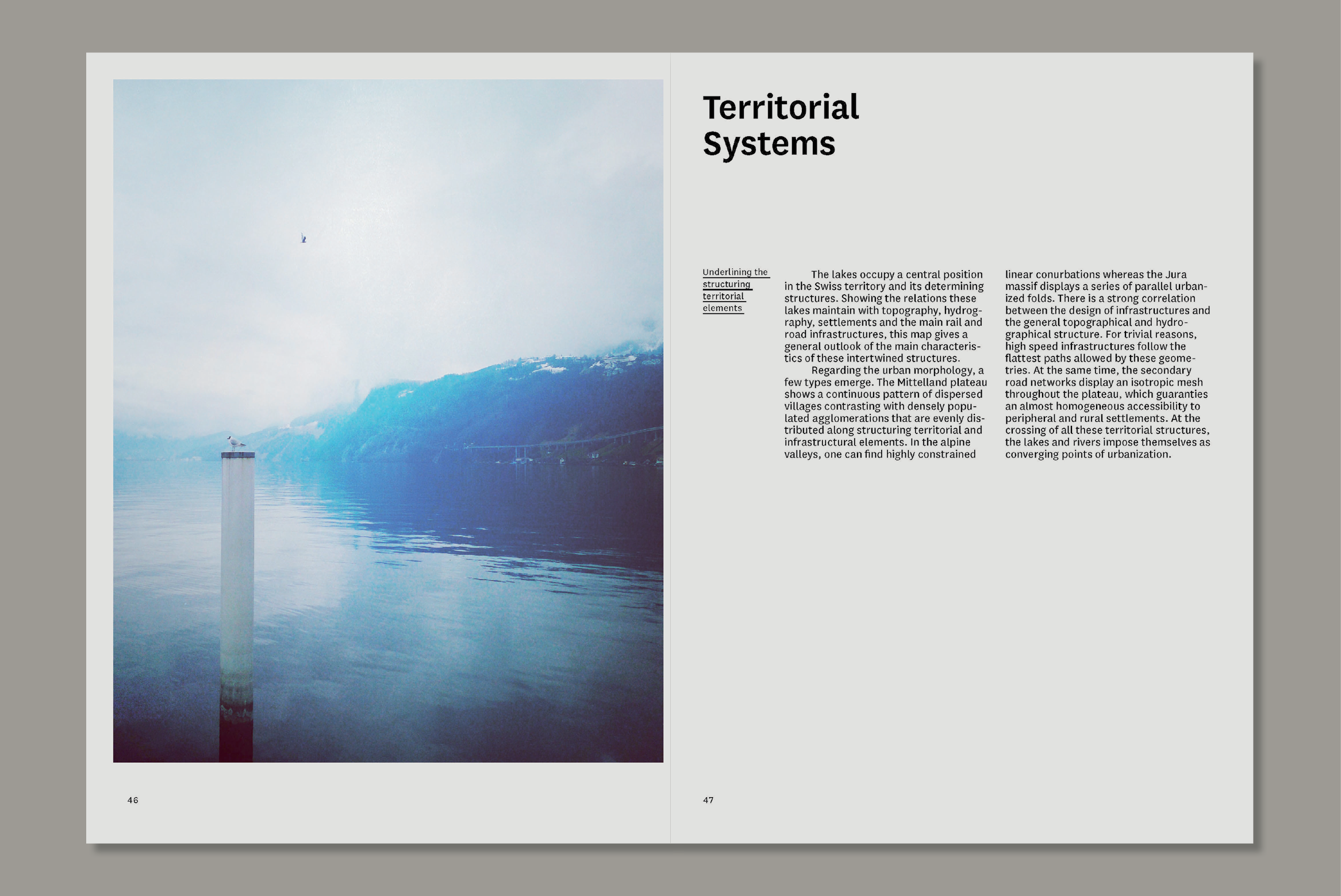
Highlighting the structuring territorial elements
The lakes occupy a central position in the Swiss territory and its determining structures. By showing the relationship of the lakes with the topography, hydrography, settlement and the main rail and road infrastructures, this map gives a general overview of the main characteristics of these interlocking structures. As far as urban morphology is concerned, some types emerge. The Mittelland plateau shows a continuous pattern of dispersed villages contrasting with densely populated settlements evenly distributed along structuring territorial and infrastructural elements. In the Alpine valleys there are highly constrained linear settlements. In the Alpine valleys there are highly constrained linear conurbations, whereas the Jura massif has a series of parallel urbanised folds. There is a strong correlation between infrastructure design and the general topographic and hydrographic structure. For trivial reasons, high-speed infrastructure follows the flattest trajectories allowed by these geometers. At the same time, the secondary road networks have an isotropic grid over the whole plateau, which guarantees a quasi-homogeneous accessibility to peripheral and rural settlements. At the intersection of all these territorial structures, lakes and rivers stand out as focal points of urbanisation.
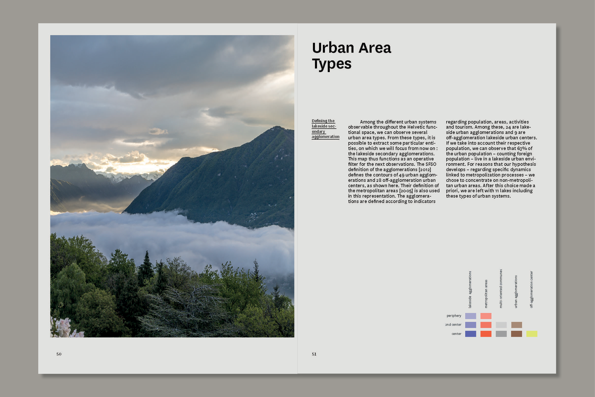
The secondary agglomeration on the lake shore
Among the different urban systems that can be observed in the Swiss functional space, we can observe several types of urban areas. From these types, it is possible to extract particular entities, on which we will focus from now on: the secondary lakeside agglomerations. This map therefore functions as an operational filter for the following observations. The FSO's definition of agglomerations [2012] defines the contours of 49 urban agglomerations and 28 urban centres outside the agglomeration, as illustrated here. Their definition of metropolitan areas [2005] is also used in this representation. The agglomerations are defined according to indicators relating to population, area, activities and tourism. Of these, 24 are lakeside urban agglomerations and 9 are non-agglomeration lakeside urban centres. If we take into account their respective populations, we can observe that 63% of the urban population - including the foreign population - lives in an urban lake environment. For reasons which our hypothesis develops - concerning the specific dynamics linked to the processes of metropolisation - we have chosen to focus on non-metropolitan urban areas. After this a priori choice, we are left with 11 lakes comprising these types of urban systems.
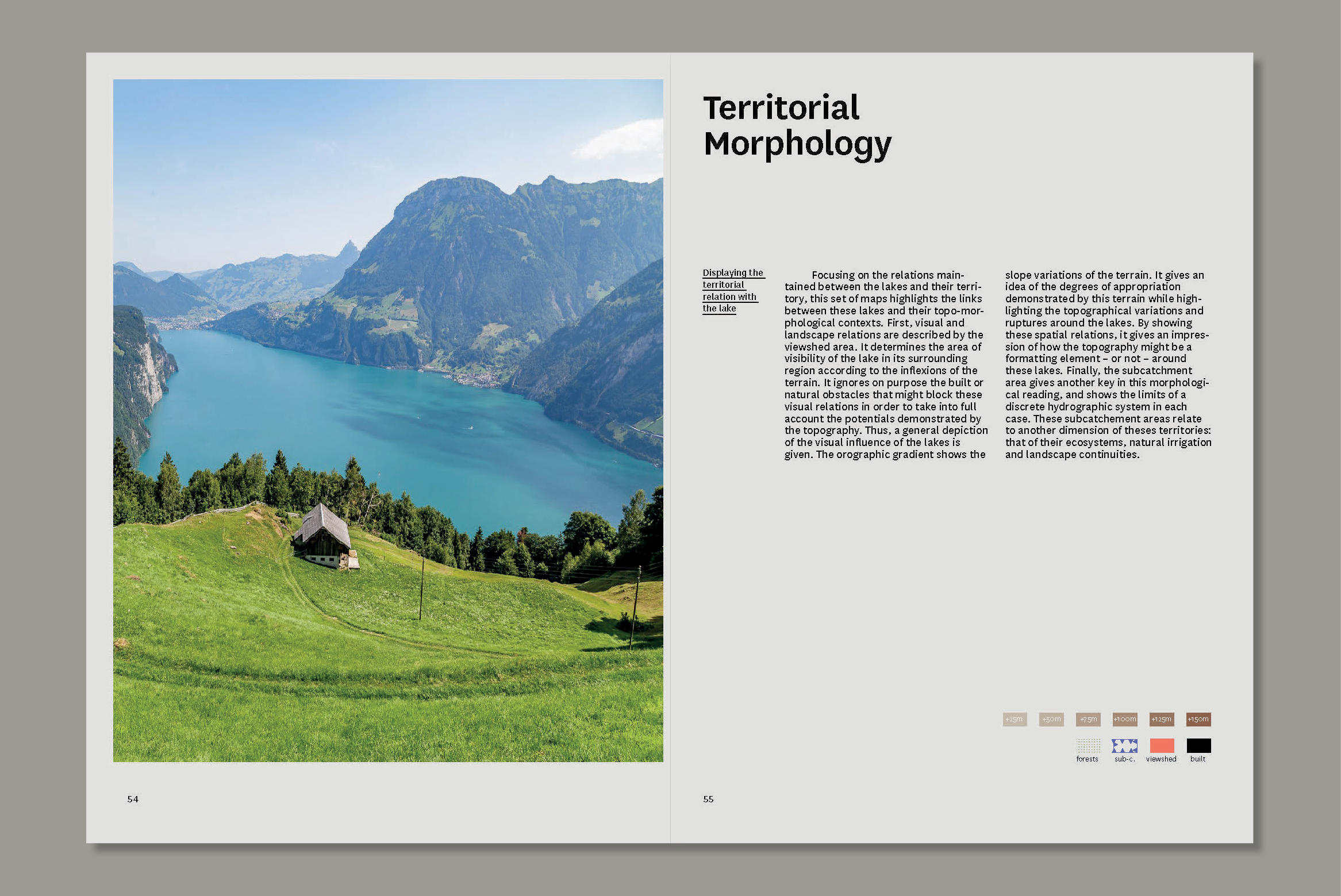
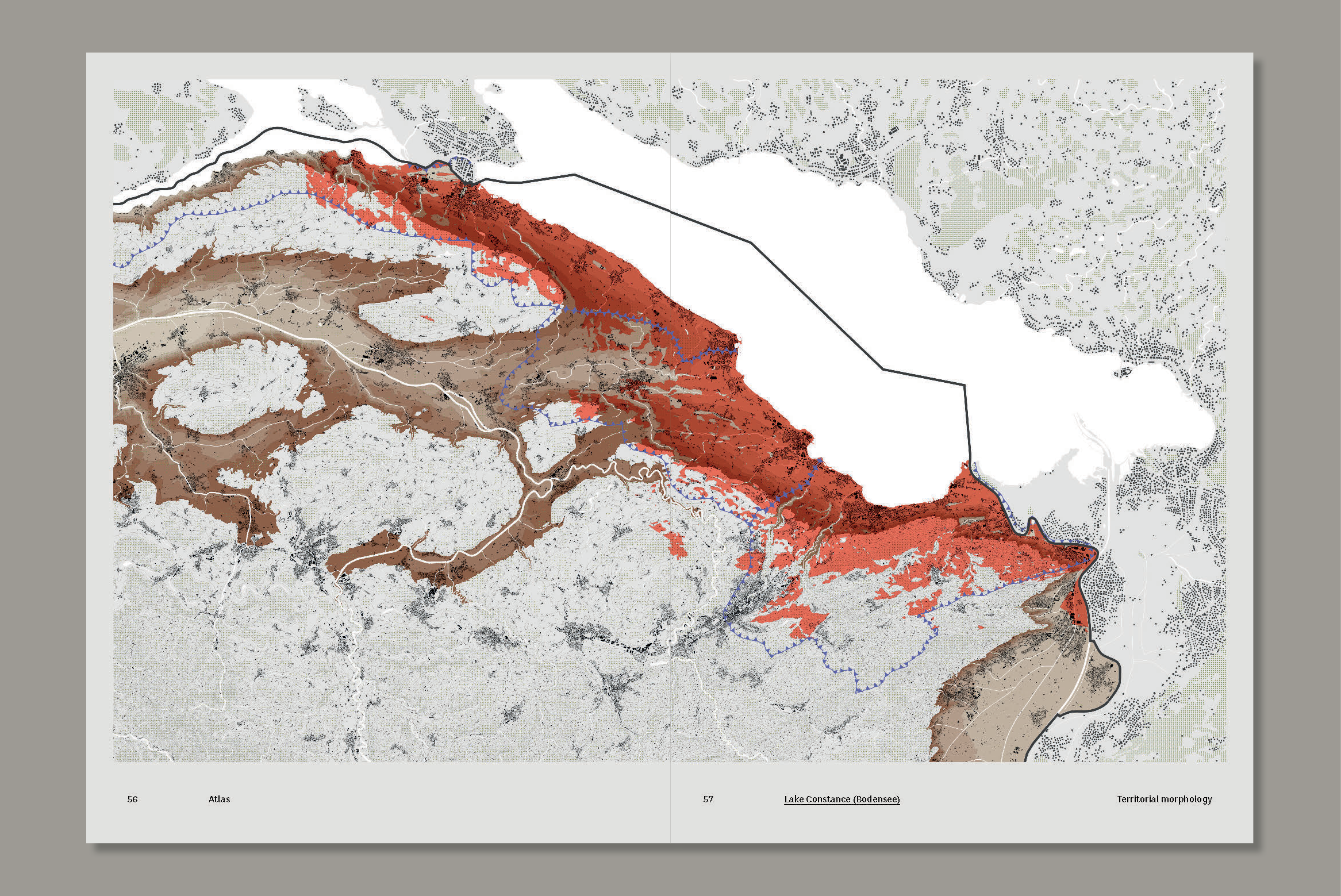
Territory-lake relationship
By focusing on the relationships between the lakes and their territory, this set of maps highlights the links between these lakes and their topo-morphological contexts. Firstly, the visual and landscape relationships are described by the visual cone surface. It determines the area of visibility of the lake in its surrounding region according to the inflections of the terrain. It deliberately ignores built or natural obstacles that could block these visual relationships in order to take into account the potentials demonstrated by the topography. Thus, a general representation of the visual influence of the lakes is given. The orographic gradient shows the variations in slope of the terrain. It gives an idea of the degrees of appropriation of the land and highlights the topographic variations and breaks around the lakes. By showing these spatial relationships, it gives an idea of how topography can be a formatting element - or not - around these lakes. Finally, the sub-catchment area provides another key in this morphological reading, and shows the limits of a discrete hydrographic system in each case. These sub-catchment areas refer to another dimension of these territories: that of their ecosystems, natural irrigation and landscape continuities.
Type of work: Master thesis
Contex: Ecole Polytechnique Fédérale de Lausanne
Study period: 2015
Authors: Allan Cunningham, Max Florean
Teachers: Prof. Harry Gugger, Barbara Costa, Prof. Luca Ortelli
A spatial concept for a metropolitan area
Swiss Lakes observes the urbanisation of Switzerland by focusing on its lakes. It examines how these territorial marks have influenced and are still influencing the different forms of urban development that can be observed throughout the country. The Swiss territory is structured by its mountainous relief and its hydrographic network: while the Alps and Jura mountain ranges represent 70% of the country's surface, their 100 largest lake counterparts - each with a surface area of more than 30 ha - develop along more than 2'200 km of shoreline (1.2 times the length of the country's borders) and occupy 5.5% of this national territory. On the other hand, in the urbanised and non-Alpine part of Switzerland, where about two thirds of the population live, the 37 lakes below 700 m in altitude represent 2,075 km2 out of a total of 2,180 km2 of lakes. This represents 17% of the 12'400 km2 of non-Alpine territory. Although they guide and constrain the spatial development of the cities on the plateau, these lakes have major potentialities and qualities: they are central voids which organise their periphery, unbuilt public spaces, breathing spaces in the landscape, framings and/or panoramas of their environment, but also places of particular frequentation, places of particular economic interests, places of particular identities and characters.
A territorial hypothesis
Swiss lakes have fascinated many painters, filmmakers and writers, as they have been a means of perceiving and imagining the depth of this territory. Could they become a means of perceiving and imagining the urban? By establishing a comparative atlas, Swiss Lakes gives the reader an overview of the different schematic urban structures that can be identified along these lake shores and hinterlands. For each theme, an isolated view of each large lake is provided, so that the reader can easily compare the different urban phenomena that can be observed between these lakes. The second part of Swiss Lakes proposes a hypothesis for the future urban and demographic development of the country. It is intended to be read in parallel to the atlas, in no particular order.
This hypothesis starts from a territorial state as a resource for the project: the inherited topography of Switzerland and its inherited urban network. By adopting an extreme postulate - that of a hypothetical Switzerland of 15 million inhabitants - we will observe how the mechanisms and schematic structures observed in the comparative atlas could be used to meet the needs of such a hypothetical Switzerland. Through manipulation, how could these models and their network support a harmonious metropolisation and an optimised densification of the Swiss region? How could they intensify its sub-network of secondary cities and retain their specificities, while realistically coping with the dominance of three large metropolitan regions? In other words: how can we imagine using a structuring territory as a resource for a structured metropolisation?
Highlighting the structuring territorial elements
The lakes occupy a central position in the Swiss territory and its determining structures. By showing the relationship of the lakes with the topography, hydrography, settlement and the main rail and road infrastructures, this map gives a general overview of the main characteristics of these interlocking structures. As far as urban morphology is concerned, some types emerge. The Mittelland plateau shows a continuous pattern of dispersed villages contrasting with densely populated settlements evenly distributed along structuring territorial and infrastructural elements. In the Alpine valleys there are highly constrained linear settlements. In the Alpine valleys there are highly constrained linear conurbations, whereas the Jura massif has a series of parallel urbanised folds. There is a strong correlation between infrastructure design and the general topographic and hydrographic structure. For trivial reasons, high-speed infrastructure follows the flattest trajectories allowed by these geometers. At the same time, the secondary road networks have an isotropic grid over the whole plateau, which guarantees a quasi-homogeneous accessibility to peripheral and rural settlements. At the intersection of all these territorial structures, lakes and rivers stand out as focal points of urbanisation.
The secondary agglomeration on the lake shore
Among the different urban systems that can be observed in the Swiss functional space, we can observe several types of urban areas. From these types, it is possible to extract particular entities, on which we will focus from now on: the secondary lakeside agglomerations. This map therefore functions as an operational filter for the following observations. The FSO's definition of agglomerations [2012] defines the contours of 49 urban agglomerations and 28 urban centres outside the agglomeration, as illustrated here. Their definition of metropolitan areas [2005] is also used in this representation. The agglomerations are defined according to indicators relating to population, area, activities and tourism. Of these, 24 are lakeside urban agglomerations and 9 are non-agglomeration lakeside urban centres. If we take into account their respective populations, we can observe that 63% of the urban population - including the foreign population - lives in an urban lake environment. For reasons which our hypothesis develops - concerning the specific dynamics linked to the processes of metropolisation - we have chosen to focus on non-metropolitan urban areas. After this a priori choice, we are left with 11 lakes comprising these types of urban systems.
Territory-lake relationship
By focusing on the relationships between the lakes and their territory, this set of maps highlights the links between these lakes and their topo-morphological contexts. Firstly, the visual and landscape relationships are described by the visual cone surface. It determines the area of visibility of the lake in its surrounding region according to the inflections of the terrain. It deliberately ignores built or natural obstacles that could block these visual relationships in order to take into account the potentials demonstrated by the topography. Thus, a general representation of the visual influence of the lakes is given. The orographic gradient shows the variations in slope of the terrain. It gives an idea of the degrees of appropriation of the land and highlights the topographic variations and breaks around the lakes. By showing these spatial relationships, it gives an idea of how topography can be a formatting element - or not - around these lakes. Finally, the sub-catchment area provides another key in this morphological reading, and shows the limits of a discrete hydrographic system in each case. These sub-catchment areas refer to another dimension of these territories: that of their ecosystems, natural irrigation and landscape continuities.